Call us now :07971189175

 Send Inquiry
Trans CAD
MOQ : 1 Piece
Trans CAD Specification
- Interface Type
- Graphical User Interface (GUI)
- Security Features
- Password Protected Access
- Compatible System
- Windows Operating System
- Language Support
- English
- Support System
- Technical Support Available
- Usage
- Transport Data Analysis and Modeling
- Capacity (Person)
- Multi-user Capability
- Type
- Desktop Application
- Application
- GIS Software for Transport Planning
- Installation Type
- Offline Installer Package Available
- Customization
- Customizable Modules on Demand
- Integration
- Integrates with Other GIS and CAD Software
- Update Frequency
- Periodic Software Updates Available
- Data Security
- Encrypted Database Storage
- System Requirements
- Minimum 2GB RAM, 1.5GHz processor, 500MB Disk Space
- User Manual
- Comprehensive Documentation Provided
- License Type
- Commercial License
- Visualization Tools
- Advanced Mapping and Reporting Features
- Data Import/Export
- Supports Multiple Formats including CSV, Excel, GIS
Trans CAD Trade Information
- Minimum Order Quantity
- 1 Piece
- Supply Ability
- 10 Pieces Per Week
- Delivery Time
- 4-12 Week
About Trans CAD
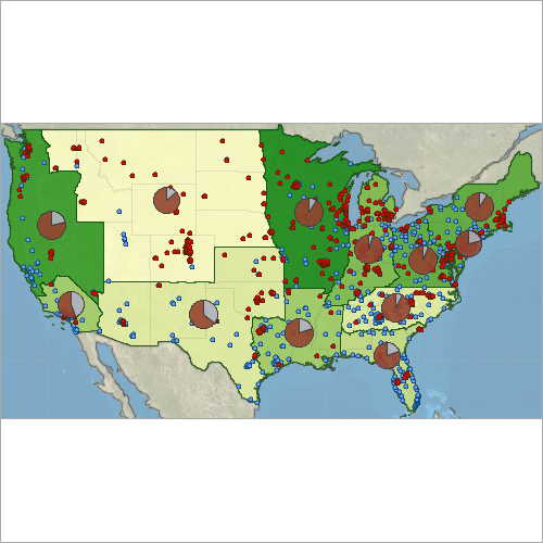
Trans CAD: is the first and only Geographic Information System (GIS) designed specifically for use by transportation professionals to store, display, manage, and analyze transportation data. Trans CAD combines GIS and transportation modeling capabilities in a single integrated platform, providing capabilities that are unmatched by any other package.
Trans CAD is the first and only Geographic Information System (GIS) designed specifically for use by transportation professionals to store, display, manage, and analyze transportation data. Trans CAD combines GIS and transportation modeling capabilities in a single integrated platform, providing capabilities that are unmatched by any other package. TransCAD can be used for all modes of transportation, at any scale or level of detail. TransCAD provides:
- A powerful GIS engine with special extensions for transportation
- Mapping, visualization, and analysis tools designed for transportation applications
- Application modules for routing, travel demand forecasting, public transit, logistics, site location, and territory management
Trans CAD has applications for all types of transportation data and for all modes of transportation, and is ideal for building transportation information and decision support systems. TransCAD runs on readily-available hardware under Microsoft Windows and embraces virtually all desktop computing standards. This has two important benefits:
- You can acquire and install Trans CAD at a much lower cost than any other integrated GIS and transportation modeling solution
- You dont have to build custom applications or complicated data interchange modules to perform transportation analysis with GIS data
Efficient Transport Planning with Trans CAD
Trans CAD streamlines the process of transport data analysis with its advanced visualization tools and comprehensive reporting capabilities. The software empowers users to make data-driven decisions with its multi-format data support and integration with various GIS and CAD applications, ensuring seamless workflow for complex planning projects.
Customizable Modules for Tailored Solutions
Adapt the software to your organizational requirements by utilizing Trans CAD's customizable modules available on demand. Whether you need specialized models or unique visualizations, the flexibility enables suppliers, traders, and distributors to deliver tailored solutions meeting diverse transport planning challenges in India.
Maximum Security and Reliable Performance
With features like encrypted database storage and password-protected access, Trans CAD ensures your sensitive transport data remains secure. The desktop application is optimized for multi-user environments and performs efficiently even on systems with minimum specifications, supported by periodic updates and technical assistance.
FAQ's of Trans CAD:
Q: How can I import and export transport data with Trans CAD?
A: Trans CAD supports importing and exporting data in various formats, including CSV, Excel, and GIS files. Users can easily transfer datasets for analysis or reporting by utilizing the integrated export and import tools accessible from the graphical user interface, facilitating seamless interoperability with other software.Q: What are the benefits of the commercial license for Trans CAD?
A: A commercial license provides full access to all features of Trans CAD, including multi-user functionality, advanced mapping tools, customizable modules, and technical support. It is ideal for distributors, suppliers, and service providers looking for scalable solutions in transport analytics and modeling.Q: When are software updates available for Trans CAD?
A: Trans CAD undergoes periodic software updates to enhance functionality, improve security, and ensure compatibility with the latest GIS and CAD systems. Users are notified of new release schedules, and updates can be installed offline, ensuring uninterrupted workflow and access to new features.Q: Where is Trans CAD primarily used?
A: Trans CAD is widely adopted across India by transport planning organizations, service providers, distributors, and traders. Its capabilities support GIS-based transportation analysis in both public and private sector projects, aiding in effective planning and modeling.Q: What is the process for integrating Trans CAD with other GIS or CAD software?
A: Integration is streamlined via the built-in support for common GIS and CAD formats. Data can be exchanged through direct import/export, or using the provided APIs and plugins, ensuring compatibility and enhanced workflow efficiency across multiple platforms.Q: How does Trans CAD ensure security of transport data?
A: Trans CAD utilizes encrypted database storage and password-protected access to secure sensitive project data. These security features, combined with the customizable user roles, prevent unauthorized access and maintain data integrity throughout the transport planning lifecycle.
Tell us about your requirement

Price:
Quantity
Select Unit
- 50
- 100
- 200
- 250
- 500
- 1000+
Additional detail
Mobile number
Email

More Products in Transportation Software Category
Maptitude GIS
Price Range 50000.00 - 500000.00 INR / Piece
Minimum Order Quantity : 1 Piece
Type : Other, GIS Software
Usage : Business, Personal, Industrial
Capacity (Person) : Multiuser
Support System : Windows

Sidra Intersection
Price Range 200000.00 - 500000.00 INR / Unit
Minimum Order Quantity : 1 Unit
Type : Other, Traffic Analysis Software
Usage : Intersection Analysis and Simulation
Capacity (Person) : Singleuser and Multiuser license options
Support System : Windows Operating System

Trans Modeler
Price Range 50000.00 - 500000.00 INR / Piece
Minimum Order Quantity : 1 Piece
Type : Other, Simulation Software
Usage : Modelling and Analyzing Urban Traffic
Capacity (Person) : Multiuser
Support System : Online Support, Offline Documentation

Sidra Trip 1.1 Unique Software for Vehicle Trip
Price Range 200000.00 - 500000.00 INR / Unit
Minimum Order Quantity : 1 Unit
Type : Other, Vehicle Trip Management Software
Usage : Software for Vehicle Trip Tracking
Capacity (Person) : MultiUser
Support System : Technical Support Available
We are providing our products across India.
Our Products

B-302, Taj Enclave, Geeta Colony,Delhi - 110031, India

 Send Inquiry
 Send SMS
Developed and Managed by Infocom Network Private Limited.
