Call us now :07971189175

 Send Inquiry
Maptitude GIS
MOQ : 1 Piece
Maptitude GIS Specification
- Compatible System
- Windows
- Language Support
- English
- Security Features
- High security with user authentication
- Interface Type
- Digital
- Support System
- Windows
- Capacity (Person)
- Multiuser
- Usage
- Business, Personal, Industrial
- Type
- GIS Software
- Application
- Industrial
- Update Support
- Yes, with regular software patches
- Processor Requirement
- Intel i3 or above
- Connectivity
- Offline/Online
- RAM Requirement
- Minimum 4 GB
- Product Name
- Maptitude GIS
- Map Formats Supported
- .shp, .tab, .dwg, .dxf, .csv, .kml
- Storage Temperature
- 5-40 Degree Celsius
- Installation Service
- Available
- License Type
- Single User/Enterprise
- Packaging Type
- Box
Maptitude GIS Trade Information
- Minimum Order Quantity
- 1 Piece
- Supply Ability
- 10 Pieces Per Week
- Delivery Time
- 4-12 Week
About Maptitude GIS
Maptitude: Maptitude Geographic Information System (GIS) software gives you the tools, maps, and demographic data you need to analyze and understand how geography affects you and your business. Every day you have to contend with spreadsheets and databases filled with vast amounts of customer, employee, sales, facility, and territory data.
Maptitude Geographic Information System (GIS) software gives you the tools, maps, and demographic data you need to analyze and understand how geography affects you and your business. Every day you have to contend with spreadsheets and databases filled with vast amounts of customer, employee, sales, facility, and territory data. With Maptitude mapping software you can visualize data in new and different ways, unearth geographic patterns hidden in your data, and convey that information in a straightforward manner. Maptitude provides everything you need to realize the benefits of desktop mapping and spatial analysis with a single, easy-to-use package. With Maptitude you can:
- Know exactly where your customers are
- See where sales are highest
- Find hidden opportunities
- Spot geographic patterns and trends that cannot be seen in database tables and spreadsheets
- Answer geographic questions that impact your operations
Maptitude has the richest feature set and highest performance of any mapping software. Maptitude offers comprehensive desktop mapping software functionality and provides many new and enhanced features that make it easier for you to create and edit maps, add your data to maps, analyze geographic data, and connect to corporate data resources.
Comprehensive Map Format Support
Maptitude GIS enables users to work with an extensive range of map file formats, such as .shp, .tab, .dwg, .dxf, .csv, and .kml. This multi-format compatibility ensures seamless integration with existing datasets and simplifies migration from other GIS platforms, making it ideal for diverse industrial and business mapping needs.
High Security and User Authentication
Security is a priority in Maptitude GIS with robust user authentication systems. This feature protects sensitive geographic data and restricts access to authorized users only. Whether for personal, business, or enterprise use, data integrity and privacy are rigorously safeguarded.
Reliable Update and Installation Support
Regular software update patches keep your Maptitude GIS secure and on the cutting edge of technology. Professional installation services are available to ensure seamless setup and operation, enhancing user experience and productivity for both new and existing clients across India.
FAQ's of Maptitude GIS:
Q: How do I install Maptitude GIS on my Windows computer?
A: Maptitude GIS can be installed on any computer running Windows with at least 4 GB RAM and an Intel i3 processor or above. Installation services are offered by authorized distributors and providers throughout India to ensure a smooth setup process.Q: What map formats are supported in Maptitude GIS?
A: The software supports a wide range of formats including .shp, .tab, .dwg, .dxf, .csv, and .kml, which allows versatile use for various mapping and data analysis projects.Q: When are software updates and patches available for Maptitude GIS?
A: Regular software patches are provided to all users of Maptitude GIS, ensuring continuous improvement, enhanced security, and the latest GIS features regardless of license type.Q: Where can I get installation support for Maptitude GIS in India?
A: Installation and support services are available through authorized distributors, service providers, suppliers, and traders located throughout India. These professionals can assist with setup, troubleshooting, and ongoing maintenance.Q: What is the user authentication process in Maptitude GIS?
A: Maptitude GIS employs robust user authentication mechanisms, requiring each user to log in with unique credentials. This protects sensitive data and ensures only authorized users have access to GIS resources.Q: How can businesses benefit from using Maptitude GIS?
A: Businesses can leverage Maptitude GIS to streamline geographic analysis, optimize site selection, enhance logistics, and manage assets efficiently. Its ability to handle various map formats and multiuser capacity makes it perfect for collaborative industrial environments.Q: Is offline connectivity available for Maptitude GIS?
A: Yes, Maptitude GIS supports both offline and online connectivity, allowing users flexibility to work in a variety of environments, including secure or remote locations.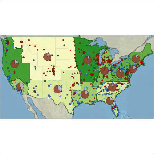
Tell us about your requirement

Price:
Quantity
Select Unit
- 50
- 100
- 200
- 250
- 500
- 1000+
Additional detail
Mobile number
Email

More Products in Transportation Software Category

Sidra Trip 1.1 Unique Software for Vehicle Trip
Price Range 200000.00 - 500000.00 INR / Unit
Minimum Order Quantity : 1 Unit
Language Support : Multiple Languages
Interface Type : UserFriendly GUI
Support System : Technical Support Available
Usage : Software for Vehicle Trip Tracking
Trans CAD
Price Range 50000.00 - 500000.00 INR / Piece
Minimum Order Quantity : 1 Piece
Language Support : English
Interface Type : Graphical User Interface (GUI)
Support System : Technical Support Available
Usage : Transport Data Analysis and Modeling
Trans Modeler
Price Range 50000.00 - 500000.00 INR / Piece
Minimum Order Quantity : 1 Piece
Language Support : English
Interface Type : Graphical User Interface (GUI)
Support System : Online Support, Offline Documentation
Usage : Modelling and Analyzing Urban Traffic

Sidra Intersection
Price Range 200000.00 - 500000.00 INR / Unit
Minimum Order Quantity : 1 Unit
Language Support : English
Interface Type : Graphical User Interface (GUI)
Support System : Windows Operating System
Usage : Intersection Analysis and Simulation
We are providing our products across India.
Our Products

B-302, Taj Enclave, Geeta Colony,Delhi - 110031, India

 Send Inquiry
 Send SMS
Developed and Managed by Infocom Network Private Limited.
